How Drone Photogrammetry Is Changing the Way Florida Developers Document Construction Projects
Florida's construction industry is running at a pace that would have been unimaginable a decade ago. With the state's population approaching 23.4 million residents in 2025 — up nearly 9% since 2020 — developers across Miami, Tampa, Orlando, and Jacksonville are managing some of the largest and most complex builds in the country. And they're discovering that the methods they used to document those projects haven't kept up.
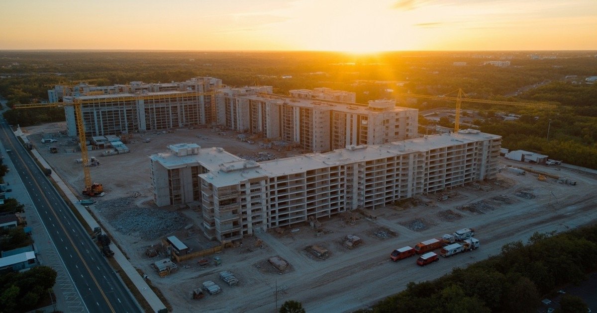
Traditional site photography captures fragments: a few ground-level shots from a superintendent's phone, a handwritten log, maybe a GPS-enabled photo at key milestones. It's data, but it's disconnected, subjective, and impossible to compare across time without significant manual effort. The result is that developers, lenders, and ownership groups often lack a clear, objective picture of what's actually happening on a site — until problems surface.
Drone photogrammetry is rapidly becoming the standard for construction documentation in Florida. By capturing high-resolution aerial imagery and processing it into measurable, georeferenced models, it gives project teams a continuous digital record that replaces guesswork with precision. The shift isn't theoretical. It's showing up in faster approvals, fewer disputes, and measurable cost savings on active projects across the state.
The Documentation Problem on Florida's Busiest Sites
Florida's construction market in 2026 is defined by two competing pressures: unprecedented demand and persistent constraints. Strong population growth, commercial development, and major infrastructure programs are fueling project pipelines that span residential, industrial, hospitality, and civil sectors. At the same time, labor shortages — particularly in project management, estimating, and skilled trades — are making it harder to execute those projects with traditional methods.
In this environment, documentation tends to fall by the wayside. Site teams are stretched thin. Ground-level photography misses overhead conditions. Traditional surveys are slow, expensive, and require specialized crews that are in short supply. For developers managing multiple projects simultaneously, the gap between what's being built and what's being recorded is a risk that compounds over time.
The consequences show up in three recurring pain points. First, progress verification becomes a subjective conversation rather than an objective record. Lenders and ownership groups rely on site visits or self-reported updates that may not reflect the full picture. Second, disputes over schedule delays or scope changes are difficult to resolve without comprehensive visual evidence tied to specific dates. Third, quality control depends on walking the site manually — a process that works for small projects but becomes impractical at scale.
What Drone Photogrammetry Actually Delivers
Drone photogrammetry is the process of capturing overlapping aerial photographs with a calibrated sensor and processing them into georeferenced spatial data: orthomosaic maps, digital surface models, point clouds, and 3D meshes. Each deliverable serves a different purpose, but they all share a common value: they represent the site as it existed at a specific moment in time, captured from above with centimeter-level accuracy.
An orthomosaic map provides a precise, photo-realistic top-down view of the entire site — every structure, access road, stockpile, and equipment placement in a single, measurable image. Unlike a satellite view, an orthomosaic from a drone flight is captured at low altitude, processed with RTK or PPK corrections, and georeferenced to real-world coordinates. A developer can measure distances, compare layouts against design files, and share the result with stakeholders anywhere in the world.
A digital surface model (DSM) adds elevation data, enabling cut-and-fill calculations, stockpile volume measurements, and grading verification without a separate topographic survey. For sites undergoing mass grading or civil infrastructure work, this is particularly valuable — volume estimates that once required a survey crew can now be generated from a 45-minute flight.
The 3D model or point cloud goes further, enabling clash detection against BIM files, progress comparisons over time, and a comprehensive site record that serves multiple teams — design, construction, ownership, and financing — from a single dataset.
The Numbers Behind the Technology
Data from multiple industry sources and case studies makes the value proposition concrete.
According to research published in 2025, drone surveys reduce construction site field time by 60 to 80 percent compared to traditional ground methods, while cutting costs by up to 90 percent for large-area projects. For a 50-acre site, a drone photogrammetry survey costs approximately $250 to $1,250, compared to $5,000 to $25,000 or more for traditional ground methods — a gap that widens considerably on larger projects.
When integrated into a recurring monitoring workflow, the downstream effects are significant. A documented case study involving New York-based Wesbuilt Construction — a firm managing complex multi-phase builds — found that bi-weekly 3D scans for progress tracking and documentation produced a 61 percent reduction in document errors and omissions, a 36 percent reduction in rework hours, and a 22 percent faster project completion timeline. The same study documented 17 percent fewer claims and litigation events, outcomes directly tied to having a precise, time-stamped record of site conditions.
McKinsey research from 2025 indicates that digital transformation in construction — including photogrammetry, BIM, and automated monitoring — delivers productivity gains of 14 to 15 percent and reduces overall project costs. Florida's construction sector, representing a substantial share of the state's economic activity, is among the most active adopters of these technologies in the country.
For Florida developers specifically, the relevance goes beyond productivity. Florida's population growth and diverse terrain — from dense urban cores in Miami to large-format industrial sites in the I-4 corridor — create documentation challenges that are difficult to solve with traditional approaches. Drone photogrammetry scales to both environments without requiring additional crew members or extended site access.
Regulatory Compliance and the FAA Framework
Operating drones for commercial documentation work in Florida requires compliance with the FAA's Part 107 Small UAS Rule, which governs all commercial drone operations in the United States. Part 107 requires a Remote Pilot Certificate, drone registration, and adherence to operational limitations including a maximum altitude of 400 feet AGL and visual line of sight requirements.
For construction documentation flights, additional regulatory considerations apply. Operations in controlled airspace — present around major Florida airports and certain Class E zones — require prior authorization through LAANC or a manual waiver application. Drones must have Remote ID compliance, either built-in or via an attached broadcast module. And operators conducting work on behalf of developers or general contractors should carry commercial general liability insurance — $1 million is the standard threshold for construction site drone operations.
A significant regulatory shift is approaching. The FAA's proposed Part 108 and Part 146 regulations, expected to be finalized in 2026, will introduce new frameworks for Beyond Visual Line of Sight (BVLOS) operations and Automated Data Service Providers. Once finalized, these rules will streamline the approval process for recurring monitoring flights and automated operations at construction sites. For developers currently operating under Part 107 with individual flight authorizations, Part 108 promises to reduce the administrative burden of large-scale or multi-site programs significantly.
For now, the practical compliance steps are straightforward: verify the pilot's Part 107 certification and renewal status, confirm airspace authorization for the project site, ensure Remote ID compliance, and include drone documentation requirements in vendor contracts. These steps take minimal effort and eliminate the risk of operating without proper authorization — an enforcement priority the FAA has reinforced in 2025 and 2026.
A Practical Workflow for Florida Developers
Implementing drone photogrammetry on a Florida construction site follows a repeatable workflow that fits within existing project management structures.
The process begins before mobilization: confirming the site location and airspace classification, obtaining LAANC authorization if required, and coordinating with the site superintendent to ensure safe flight conditions and ground crew awareness. A typical flight for a medium-scale commercial site takes 30 to 60 minutes, capturing overlapping imagery at 70 to 80 percent overlap to ensure accurate processing.
After the flight, the imagery is processed using photogrammetry software to generate orthomosaic maps, DSMs, and point clouds. Depending on the site size and deliverable requirements, initial results are typically available within 24 to 48 hours. These deliverables can be shared directly with project stakeholders, integrated into BIM or project management platforms, or archived as part of a comprehensive project record.
For ongoing projects, the most valuable application is recurring documentation — monthly or bi-weekly flights that create a time-stamped visual history of the build. Each new dataset can be compared against previous flights to identify deviations from schedule, track material placement, verify completed work against draw request milestones, and maintain a defensible record for lender inspections or ownership reviews.
Why Florida Developers Are Making the Shift
The reasons Florida developers are adopting drone photogrammetry are practical, not theoretical. The Florida construction market — consistently ranked among the top growth markets in the United States — generates documentation demands that traditional methods struggle to meet at scale. Multi-site developers, in particular, benefit from standardized aerial data that works across portfolios rather than requiring bespoke site visits for every project.
Lenders and ownership groups financing large projects increasingly expect drone-based documentation as part of a modern construction reporting package. The objective, time-stamped aerial record reduces the information asymmetry that leads to prolonged approval processes, disputed draw requests, and disputes over schedule delays. When every stakeholder is looking at the same orthomosaic, taken on the same date, the conversation shifts from perception to fact.
The cost structure is also favorable. Drone photogrammetry surveys for construction sites range from $1,500 to $3,000 for small sites and $3,000 to $10,000 or more for large-area projects, according to 2026 industry pricing guides. When weighed against the cost of rework, disputed change orders, and delayed draws — all of which are common on complex Florida projects — the investment in systematic drone documentation frequently pays for itself on a single project.
For developers working across the state's highest-activity markets — Miami's mixed-use high-rises, Tampa's industrial and residential pipelines, Orlando's multifamily and hospitality projects, and Jacksonville's logistics and infrastructure work — drone photogrammetry is becoming a baseline capability rather than a differentiator. The developers who are adopting it now are building operational habits that will become industry standard within the next two to three years.
Conclusion
Florida's construction industry is moving too fast and at too large a scale for documentation methods designed for a different era. Drone photogrammetry offers a practical, cost-effective, and measurably valuable alternative to traditional site photography and periodic surveys. The technology is proven, the regulatory framework is clear, and the data supporting its ROI is consistent across sources.
For developers managing active projects in Florida, the question isn't whether drone photogrammetry belongs in their workflow — it's whether they can afford to keep operating without it.
Request a Quote
Property HDR provides drone photogrammetry and construction progress documentation services for developers, GCs, and project teams across Florida. To discuss your next project, contact us directly.
Sources
- Approach Talent USA. (2026). Florida Construction Sector Forecast 2026. https://www.approachtalentusa.com/blog/florida-construction-sector-forecast-2026
- Davron Engineering Staffing. (2026). Florida Population Boom and Construction Growth in 2026. https://www.davron.net/florida-population-boom-construction-2026
- Apex Survey. (2026). Drone & Aerial Survey Guide for Florida: Costs, Accuracy & Methods. https://apexsurvey.us/guides/drone-aerial-survey-guide
- Matterport. (2025). 3D Modeling for Construction: How AEC Professionals Can Improve Design Accuracy. https://matterport.com/blog/3d-modeling-construction
- The Future 3D. (2026). Aerial Survey Cost Guide: Pricing by Method, Area & Accuracy. https://www.thefuture3d.com/blog/aerial-survey-cost-guide
- iSCANO. (2025). Construction Progress Monitoring with 3D Scanning: The Complete 2026 Implementation Guide. https://iscano.com/real-world-applications-laser-scanning-lidar/construction-progress-monitoring-3d-scanning-complete-guide/
- Datumate. (2025). FAA Part 107 Rules for Drone Mapping on Construction Sites. https://www.datumate.com/blog/faa-part-107-rules-for-drone-mapping-on-construction-sites/
- DroneTrust. (2026). New FAA Rules Coming in 2026: What U.S. Drone Pilots Should Know. https://dronetrust.com/blogs/articles/new-faa-drone-rules-2026
- AeroVIEWS. (2025). How Accurate Is a Drone Survey? LiDAR, RTK & Photogrammetry. https://aeroviews.co/blog/how-accurate-is-a-drone-survey/
- SkyeBrowse. (2026). Drone Surveying: Methods, Costs & Accuracy. https://www.skyebrowse.com/news/posts/drone-surveying-guide
- JRH Engineering. (2026). 2026 Forecasted Florida Real Estate Development Report & Outlook. https://www.jrhengineering.net/post/2026-florida-real-estate-development-report