How Drone Photography Is Transforming Real Estate Listings in Florida
Florida's real estate market is among the most competitive in the nation. From the waterfront estates of Tampa Bay to the sprawling communities of Southwest Florida, buyers have more options than they did a decade ago — and they are more discerning about what they see before they schedule a showing. In this environment, a property that fails to make a strong first impression online will sit on the market while better-presented competitors move within days.
That reality has pushed aerial drone photography from a novelty into a necessity. Across the state, listing agents who invest in professional drone imagery are reporting faster sales, higher offer prices, and a measurable edge over competitors still relying exclusively on ground-level cameras. The shift is backed by hard data — and it is happening faster than many professionals anticipated.
The Numbers Behind the Shift
According to the National Association of Realtors (NAR) Technology Survey 2025, 52% of all agents now use drone photography in their listings. Among active listing agents specifically, that figure rises to approximately 80%, as tracked by ReChat and PhotoUp. Among agencies, adoption is even higher: 82% use aerial photography as part of their standard marketing package, according to joint research by NAR and Matterport.
These are not early adopters — this is mainstream. And the performance data explains why.
Listings that include aerial imagery sell 68% faster than those without, according to research published by NAR and corroborated by multiple real estate technology platforms including PhotoUp and ReChat. The same studies show that properties marketed with professional drone video command price premiums of up to 10% compared to similar properties without aerial coverage.
The financial impact is measurable at the individual transaction level. A Redfin and PhotoUp analysis found that professional photography — including drone imagery — generates between $3,400 and $11,200 more in final sale price per transaction. For a Florida home selling at the state's median price, that premium can easily exceed the cost of the photography service by a factor of ten or more.
For agents, the numbers translate into a direct business case: high-volume agents use drones at a rate 3.5 times higher than low-volume agents, according to SoldByAir research. The correlation between drone use and transaction volume is not coincidental. Listings with aerial images receive 118% more online views, generate 32% faster sales, and attract 18% more buyer inquiries, according to PhotoUp's 2025 market analysis.
Why Florida Is Particularly Well Suited for Aerial Photography
No state benefits more from drone photography than Florida — and several structural factors explain why.
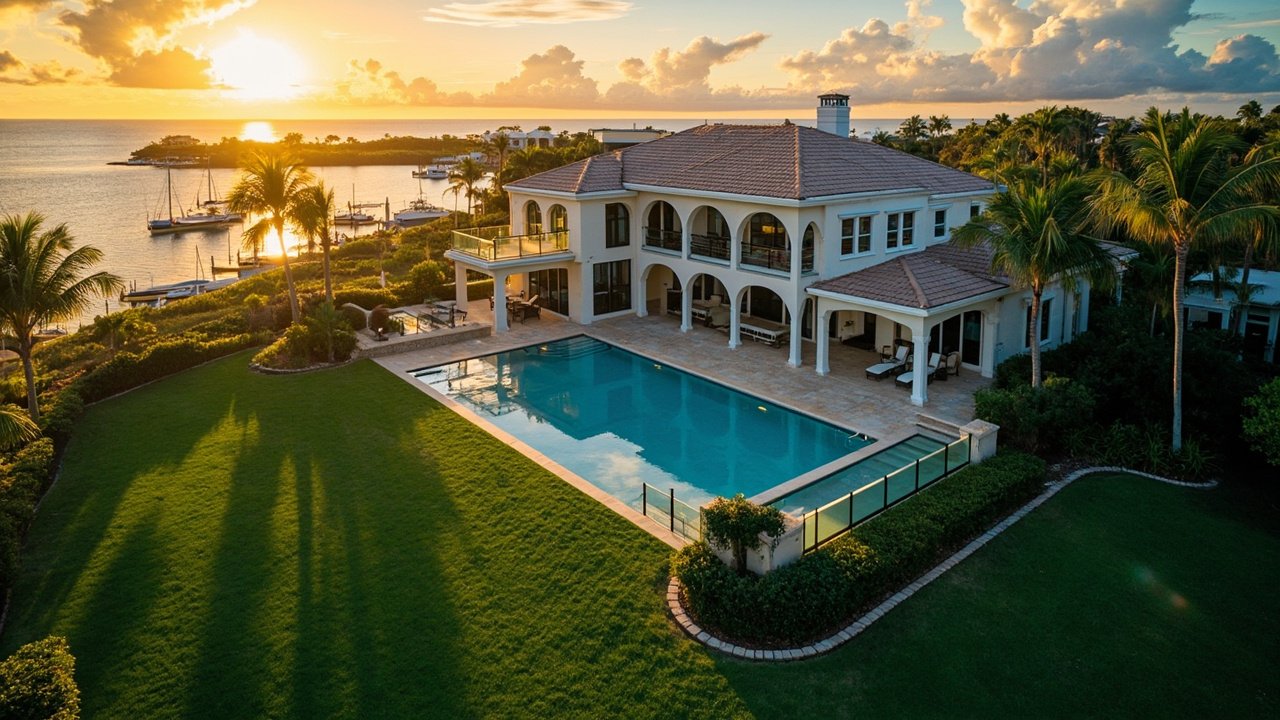
The state's topography is among the flattest in the country. Unlike mountainous regions where aerial shots are constrained by elevation changes and visibility limitations, Florida's landscape offers clean sightlines from 50 to 200 feet above ground level. This altitude range, widely accepted as optimal for residential real estate photography, captures the property's full context — roofline, lot boundaries, pool and patio areas, landscaping, and proximity to water features — without sacrificing architectural detail.
Waterfront and water-view properties represent a disproportionate share of Florida's high-value transactions. In Pinellas County, Hillsborough County, and Manatee County, waterfront and water-view listings command significant premiums. Drone shots that clearly show the relationship between a home and the water — the dock, the canal, the bay, or the Gulf access — are frequently cited by agents as the decisive factor in generating serious showings. No ground-level camera can replicate that perspective.
Florida's lot sizes also tend to be larger than the national average, particularly in suburban and semi-rural areas. Buyers purchasing a half-acre or acre-plus lot need to understand how the home sits on that land. Aerial photography delivers that context immediately, something that is simply impossible from the street.
New construction communities are another area where drone photography has become virtually essential. Florida continues to lead the nation in new residential development. For vacant land listings and master-planned communities, drone video is the most effective way to show buyers the full scope of a property and its surroundings. Ground photography in these situations is almost always inadequate.
The Buyer Expectation Curve Has Changed
Perhaps the most significant shift driving drone adoption is not agent behavior but buyer behavior. According to NAR and PhotoUp research, 57% of buyers expect to see 8 to 10 aerial images in a listing they are seriously considering. That expectation did not exist ten years ago. It has materialized in the span of a single technology cycle.
The same research shows that 65% of buyers are more likely to book a showing on a listing that includes aerial photography. And 83% of sellers, when surveyed, indicated they prefer to work with agents who use drones, reflecting the growing awareness among homeowners that professional presentation directly affects sale outcomes.
For listing agents, this expectation curve creates a clear strategic imperative. A property listed without drone photography in 2026 is not merely failing to differentiate — it is actively underperforming the market standard. In a state with Florida's inventory levels, that gap is costly.
The Business Economics of Drone Photography in 2026
The global real estate drone services market was valued at $570 million in 2025, according to the Business Research Company, and is projected to reach $1.83 billion by 2030, representing a compound annual growth rate of 16%. Those figures reflect both the rapid adoption of the technology and the sustained demand for professional aerial imagery across residential and commercial real estate markets.
On a per-transaction basis, residential drone photography services in Florida typically range from $150 to $350 for standard aerial stills, with premium packages that include video, 360-degree panoramas, and same-day delivery running between $350 and $600. For a service that demonstrably adds thousands of dollars to a sale price, the ROI calculation is straightforward.
Agents who hire professional drone operators rather than operating their own equipment represent 43% of the market, according to NAR and PhotoUp data. This reflects the growing recognition that professional results require professional operators — and that the liability, technical skill, and time investment of self-operation often outweigh the cost savings.
What Makes a Drone Photo Effective for Real Estate
Not all aerial images are created equal. Several technical and compositional factors separate genuinely effective real estate drone photography from mediocre shots that add little marketing value.
Altitude and angle. The most flattering angle for residential real estate is typically captured between 50 and 80 feet above ground — what professionals sometimes call the "elevated tripod" perspective. This altitude removes ground-level clutter such as parked cars and utility equipment while clearly showing the home's facade, roofline, and landscaping in proper proportion. Flying above 120 feet for a standard residential property typically makes the home appear insignificant, indistinguishable from a Google Earth satellite image.
Lighting. Golden hour — the period shortly after sunrise or before sunset — produces the most commercially viable exterior shots. The warm, directional light flatters both the structure and the landscape, eliminates harsh shadows on the building's faces, and creates visual depth that midday shots cannot match. Overcast days, while workable, tend to produce flat, less dynamic images.
Stabilization and resolution. Modern commercial drones such as the DJI Mavic 3 Enterprise and the DJI Inspire 3, equipped with 4K and 8K cameras, HDR sensors, and three-axis gimbal stabilization, deliver the sharpness and color fidelity that professional marketing demands. Image quality that would have required helicopter photography a decade ago is now achievable with a sub-five-pound aircraft.
Context shots. Effective drone packages go beyond a single top-down shot. They include oblique angles that show all four elevations, neighborhood context shots that demonstrate proximity to amenities, and — for waterfront properties — water approach shots that capture the dock, bulkhead, and water access from the buyer's perspective.
The Regulatory Environment: What Florida Agents Need to Know
Drone operation for commercial real estate photography in Florida is governed by Federal Aviation Administration (FAA) regulations under 14 CFR Part 107. Any drone used for commercial purposes must be registered with the FAA, and the operator must hold a valid Remote Pilot Certificate or operate under the direct supervision of a certified pilot.
In Florida, several additional local ordinances affect drone flight, particularly in coastal areas near airports, military installations, and certain municipal jurisdictions. Properties within restricted airspace — including areas near Tampa International, Southwest Florida International, and Miami International — require additional authorization through the FAA's LAANC system before flight.
Professional drone operators carry liability insurance specifically structured for commercial UAV operations. This is a non-trivial consideration for listing agents who might be tempted to operate their own equipment without proper coverage. Any agent who includes drone imagery in a listing is well advised to confirm that the operator is properly licensed and insured.
The Competitive Landscape: Why Waiting Is Not an Option
The data from Roomagen's 2026 real estate photography statistics compiled from multiple industry sources tells a clear story: drone adoption has crossed the threshold from early-adopter advantage to competitive necessity. With 82% of agencies using aerial photography and 80% of active listing agents operating with drone capability, the market that once rewarded drone photography with differentiation now penalizes its absence.
For Florida real estate professionals, the question is no longer whether to incorporate aerial imagery into listings. It is how quickly to do so, and how to ensure the quality of the footage reflects the value of the property being marketed. A waterfront estate in Sarasota deserves the same caliber of aerial presentation as a comparable property in any major coastal market in the world. The technology exists. The data supports the investment. The buyers expect it.
Professional drone photography is not a line item on a marketing budget. It is a direct investment in sale price, sale speed, and client satisfaction — and in the Florida market of 2026, it has become one of the highest-return expenditures an agent can make.
Ready to elevate your next listing? Request a Quote and discover how Property HDR's professional aerial photography and videography services can give your Florida property the market edge it deserves.